Ecosystem Layer
Connecting drones, aircraft, and fleets to UDAI.
- Fleet Registry
- GCS Integration
- Partner API Gateway
India's drone economy runs on airspace access. UDAI turns that access into shared, digital infrastructure, built for BVLOS delivery, precision agriculture, infrastructure surveillance, mapping, and eVTOL corridors.
UDAI is a single digital layer that connects everyone who touches Indian airspace: the drone or aircraft in the air, the operator flying it, and the authority governing that airspace.
It replaces manual, one-off coordination with one common system, so every registration, mission, permission, and monitoring feed runs through the same rules, in real time.
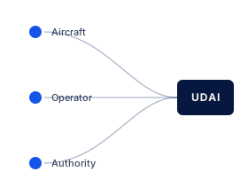
Aircraft
Operator
Authority
RegistrationMissionPermissionMonitoring
Specifications and APIs are public, not proprietary.
Any OEM, GCS, or fleet system can connect.
No operator is locked into a single provider.
Every capability is programmatic, not locked behind a portal.
Designed to carry national volumes from day one.
New applications, aircraft types, and use cases plug in without redesigning the core.
Permissions move down the stack. Telemetry and operational feeds move up.
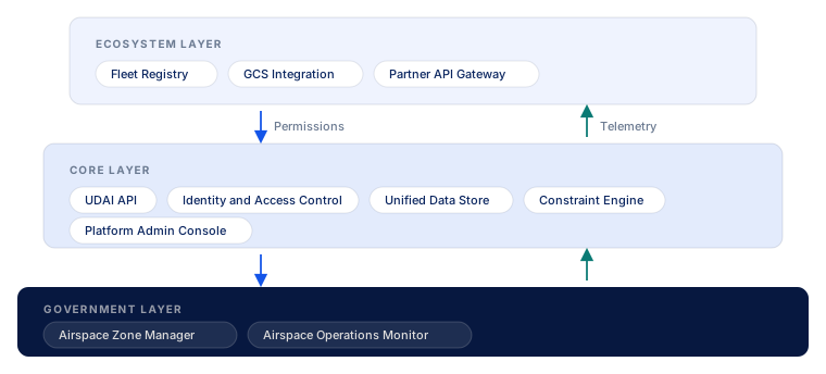
Connecting drones, aircraft, and fleets to UDAI.
The platform itself.
Giving authorities control and visibility over their airspace.
Ecosystem Layer and Government Layer share one Register, Plan, Permit, Fly, and Monitor lifecycle.
Submit a beyond-visual-line-of-sight mission against live airspace rules.
Register and operate multiple aircraft under one operator identity.
Connect a ground control station through the Partner API Gateway.
Plan and permit recurring spray and survey sorties at field scale.
Schedule corridor flights for power lines, pipelines, and towers.
Coordinate mapping missions across wide geographic extents.
Define and publish airspace constraints for a jurisdiction.
Approve missions through layered authority workflows.
Track active flights and feeds in an operations console.
Prioritise and clear airspace during incident response.
Review past missions, permissions, and zone interactions.
National rollout metrics. Each figure below carries a rollout target tag until measured data is published.
···
Registered Operators
Target
···
Zones Configured
Target
···
Missions Filed
Target
···
Permissions Processed
Target
···
Agencies Onboarded
Target
···
API Uptime
Target
Developed by Drone Federation India (DFI), with open contributions from industry.
Full specifications, a sandbox, and an integration kit, for OEMs, developers, and partners.
Organisations across the Ecosystem Layer and Government Layer that design, fly, connect, and govern aircraft in Indian airspace.